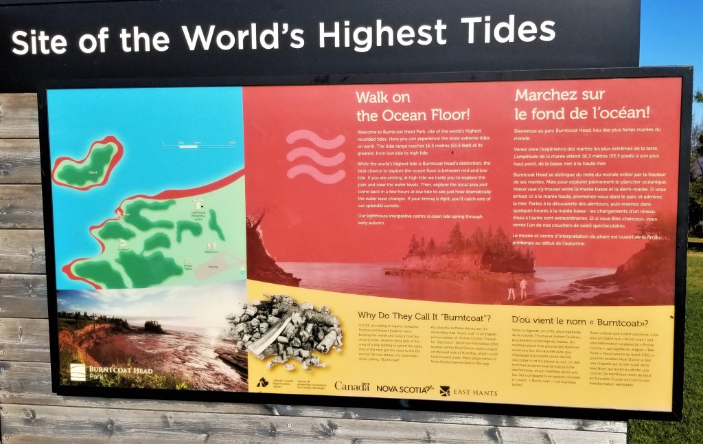
In this post, the last instalment on sightseeing in Nova Scotia, Canada. For this daytrip, we headed northwest from Halifax to Nova Scotia’s Bay of Fundy. Along the coast, Burntcoat Head Park (45 Faulkner Lane, Noel, NS) is home of the world`s highest recorded tides; at the park’s station, the average measured high tide is around 14.5 m (47.5 ft). Close to 160 billion tonnes of water flow daily into the basin every twelve hours (more than the combined flow of all freshwater rivers in the world!)
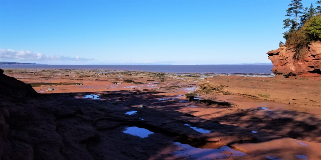
We arrived at the park around 10:30 am, just about half an hour past the predicted morning low tide for that day. The park was officially closed, as crews were still clearing brush from Hurricane Fiona’s aftermath, but visitors were allowed to access the ocean floor. There are some concrete steps that go several stories down from the parking lot level to this impressive view:
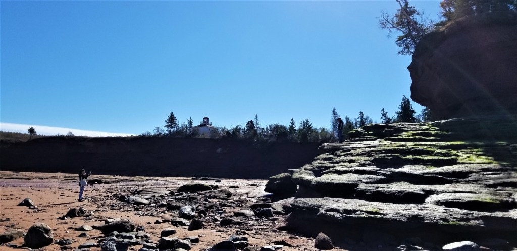
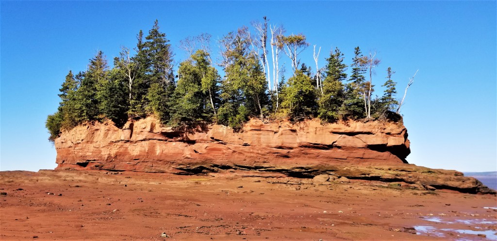
The first Burntcoat Head lighthouse was built in 1858, when a narrow neck of land connected the building to the mainland. Over time, the tides eroded this connection until the lighthouse could only be accessed by ladder. In 1913, the building was torn down and some of the wood was used in the construction of a new lighthouse on mainland. The second lighthouse operated until 1972, when it was replaced by a skeleton mast, later discontinued, leaving no guiding light left until 1994, when plans of the second lighthouse were obtained from the Coast Guard; by November of the same year, a replica was almost complete. The replica lighthouse, seen at the back of the photo below, currently operates an interpretive centre and store from May to mid-October. In the foreground, my husband at the base of the island, and our daughter taking a pic from the ocean floor, provide a scale reference of the island’s height:
Below, a profile view of Burntcoat’s island from the other side, shows light-toned soil along the upper section of its wall; the line separating from the darker soil at the bottom indicates the water levels that could be reached at the highest tides:
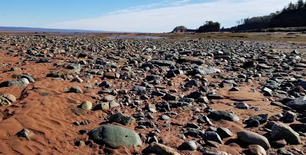
Nova Scotia’s Bay of Fundy is about 400 km (250 miles) long so, limited only by high tides and personal energy levels, it is possible to walk for hours along the emptied ocean floor of red sands, rocks and fossils:
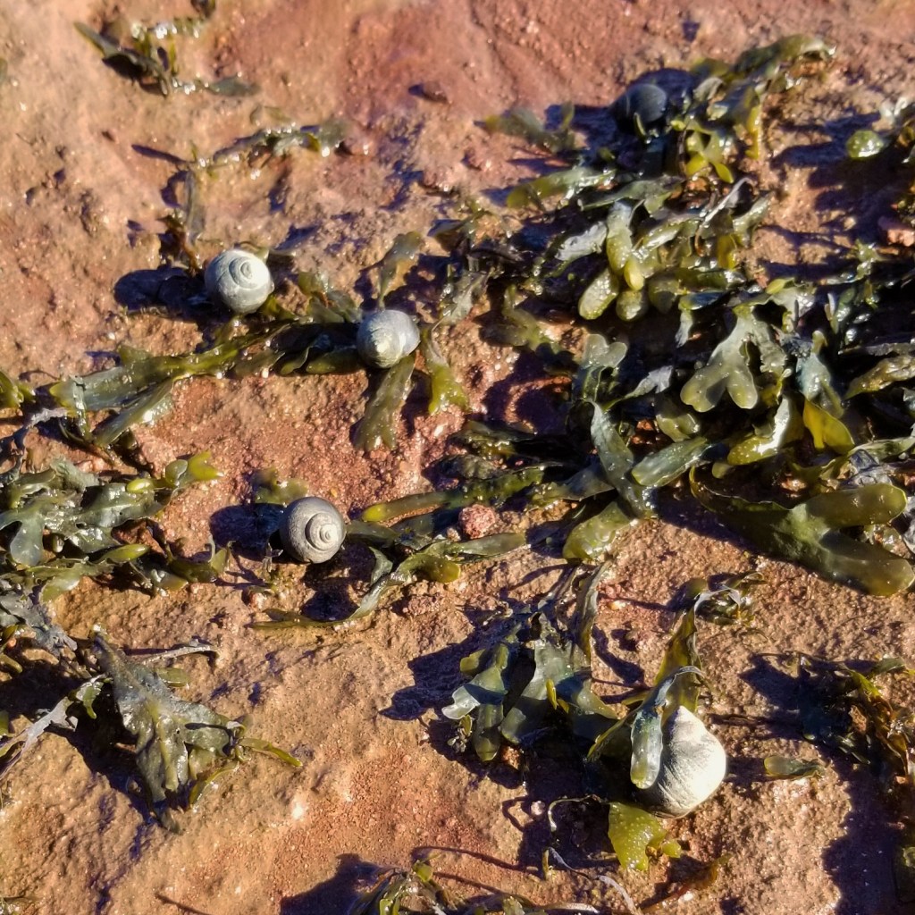
There are also many tide pools, and several colonies of small Fauna, such as the snails seen below, near seaweed growing in the ocean floor:
We were not able to wait for – or go back after – several hours to witness the high tide, but this video, by On the Coast Photography, shows a five-hour timelapse from high to low tide:
While going further west to our next stop, we got a snack at a Robin’s™, a 100% Canadian coffee chain established in 1975, that nevertheless, we did not know before. Seen below, a treat box (left) and a display of “Robin’s eggs” (right), the cute name of their donut holes (aka TimBits™ at Tim Horton’s™); we enjoyed an assortment that included chocolate-coconut, glazed and rainbow-sprinkle flavours:


We arrived at the Landscape of Grand Pré View Park (69-161 Old Post Rd, Grand Pré, NS) from which the vastness of this exceptional living agricultural land may be appreciated:

Immigrants from Acadia, France, had lived on Nova Scotia’s territory as early as 1604, when Port-Royal was founded. In the 1680s, a small group of Acadian settlers arrived to the Bay of Fundy area and called the wetlands grand pré (big meadow); by the use of dykes (or dikes) to prevent flooding by the strong tides, fertile agricultural land was claimed from the sea (called dykelands).
Modern day Grand Pré is a site of remembrance of those Acadians, who lived in congenial harmony with the native Mi’Kmaq people until, in 1713, Great Britain took control over the land. In 1730, British authorities persuaded the Acadians to agree to neutrality in any conflict between Britain and France. As tensions between the two empires grew into armed conflict, Charles Lawrence, Nova Scotia’s Lieutenant-Governor, met with Acadians in July of 1755 in Halifax, pressing the delegates to pledge allegiance to Britain. To the alarm of the Acadian delegation, when they refused, Lawrence detained them and gave the order for deportation. Later that year, Acadian males 10 years old and up were summoned to the Grand Pré parish church, where they were kept by force and then deported, separated from their families. For the next eight years, the Acadian Expulsion continued, with approximately 10,000 Acadians expelled, their possessions taken away or burnt. They were shipped to many points around the Atlantic in Canada and the US (for example, the origin of Louisiana’s Cajun culture, arts and cuisine); many were rejected and sent to France or the Caribbean, and many more died of disease or starvation while on the ships, under precarious conditions.
After this cruel episode in Acadian history, in Grand Pré, the same technology and community management were preserved by farmers of New England Planter descent, and later, by immigrants from England and Scotland, who came in the 1800s and 1900s, and by some Dutch, who arrived after World War II. In 2012, The Landscape of Grand Pré became Canada’s 16th World Heritage Site inscribed by UNESCO; at the view park, five flags are proudly displayed, as seen below, from left to right, The UN, Nova Scotia, Canada, Acadia and Mi’Kmaq flags:

Below, a short video of the panoramic view from the park:
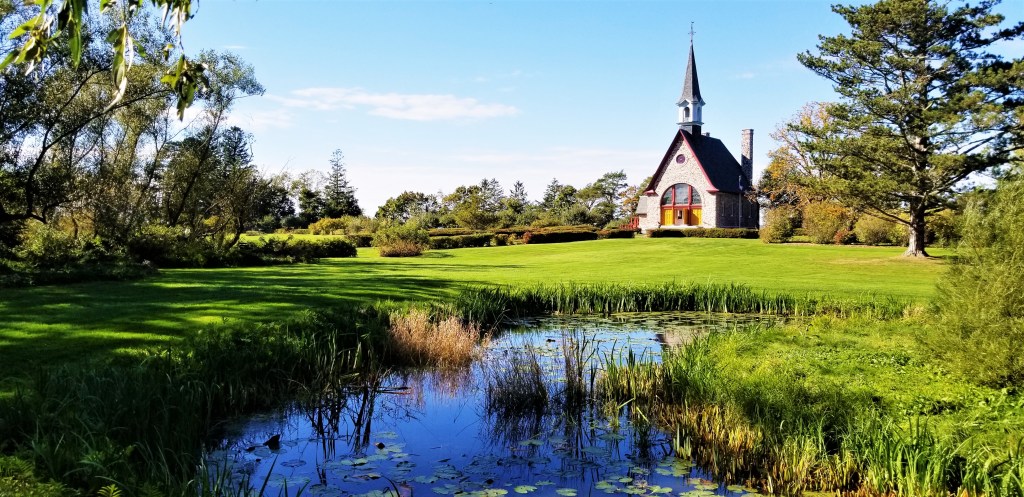
Downhill, the Grand Pré National Historic Site (2205 Grand-Pré Road, Grand Pré, NS) commemorates the period of Acadian settlement from 1682 to 1755. For many Acadians around the world, the site represents the home of their ancestors and a symbol that unites them to this day. In 1922, building of the Memorial Church was patronized by Acadian communities throughout North America, to commemorate the tragedy of The Acadian Expulsion. Since the appearance of the original pre-deportation church is unknown, the Memorial Church’s design could not be a duplicate, but archaeological excavations in 2001 suggest that it is located approximately where the original Grand-Pré parish church stood, where many Acadian men were kept prisoners before being sent away from their land and families. In the photo below, a view of the Memorial Church from the adjacent pond and Victorian garden:
To my surprise, some of the fertile lands in the Annapolis Valley are dedicated to the cultivation of grapes, and there are several wineries in the region, and really, also all over the province, even as far north as Cape Breton Island. In hindsight, it should not be that shocking after learning that the province’s latitude is around 45º North, with the wine optimal bands going from 30º to 50 º, either way from the equator, and that regional conditions, such as sloped landscapes, and dark rich soil, might also be factors for successful grape crops and tasty wines. Furthermore, French settler Louis Hébert planted the first vineyard in Bear River, Nova Scotia, in 1611, and grape growing in Nova Scotia was documented a couple of decades later by Isaac de Razilly, lieutenant-general in Acadia, who wrote, in relation to the region of Annapolis, that “Bordeaux vines have been planted that are doing very well,” making this the first written mention of wine grape cultivation anywhere in Canada.
On their website, Luckett Vineyards (1293 Grand Pré Road, Gaspereau Valley, NS) declare to be located where “crisp maritime breezes, legendary ocean tides and brilliant sunshine meet to create an outstanding terroir on a hillside overlooking the magnificent Gaspereau Valley. ” In the photo below, a corner of the bistro and store, and a view of the vineyard that corroborates the description:

The website’s homepage continues saying that “here, Luckett Vineyards captures the magic of Nova Scotia’s distinctive character through wines that truly are worth phoning home about. ” This statement is a clear reference to the real red phone booth that may be found in the middle of their grounds, as shown below:

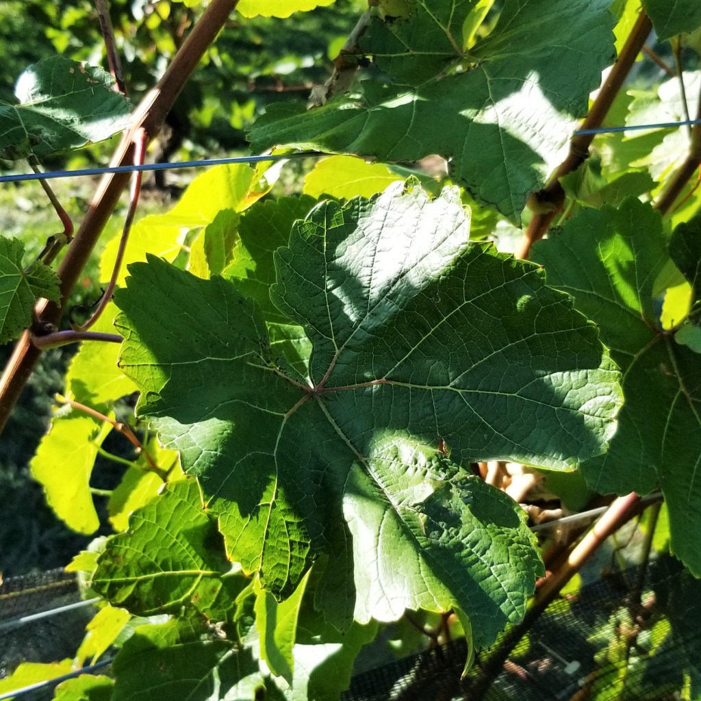
Although we missed seeing the dark grapes on the vines by a couple of weeks, the plants were still going strong, with bright and healthy leaves all around, as seen in a close-up:
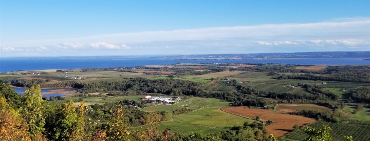
Our last stop was at the Blomidon Look-Off (3374 Highway 358, Arlington, NS), located on top of North Mountain in the Bay of Fundy & Annapolis Valley region. Although it was just a small observation area by the roadside, it gifted us with an amazing panoramic view, as seen below and at the top of this post, featuring forest, farmland and the Bay of Fundy and Minas Basin. It was a memorable way to capture a last look of all the wonderful sights of Nova Scotia’s Bay of Fundy:


Beautiful photos! The donut one makes me hungry 😋
LikeLike
A surprise to find those Robin’s eggs, 100% Canadian, and the flavours were unique, too.
LikeLiked by 1 person
I so enjoyed all the beautiful photos but I paused on the donuts 🍩… lol yummy! 😋⭐️😊
LikeLike
Hehe, I know, I could not resist including them as part of the sightseeing!
LikeLiked by 1 person
A very important part! 😉
LikeLiked by 1 person
The views at low tide are really beautiful. Hope to travel there one day. Thanks for relating the history of the Acadians.
LikeLiked by 1 person
One “run” up the Bay in the seventies left me amazed by the tidal range. I think seeing it from the shore is one thing, but in the water it’s a rather visceral experience.
LikeLike
wow I can’t even imagine how strong the tidal wave must have felt!
LikeLike
This is a wonderful travelogue! I hope to visit there in the not-too-distant
LikeLike
Thank you, Eilene; it was a wonderful experience, hope you do get to visit.
LikeLiked by 1 person
Stupid phone. …future. Thanks for the great photos, descriptions, time-lapse of the bay. Interesting to learn more details about the Acadian expulsion. We visited a museum in Louisiana where an Acadian family gathering was about to take place. The man setting up was eager to share the history with us.
LikeLiked by 1 person
😂 the chubby thumb effect I call it. I learned so much from this trip, such a tragic and rich history.
LikeLiked by 1 person